Comprehensive Coverage of Bush Walks on the Central Coast of NSW
This comprehensive list of maps includes beaches and streets as well as bush walks. All walks include a GPS map, followed while walking on the trails. The majority of the routes featured here include photos taken by recce groups from the Terrigal Trekkers, which operates from The Leisure and Learning Centre in Terrigal. I have used the popular mapping app – Alltrails.
You may wish to download the app to both your PC and your smartphone. The app is free. However, you can pay for excellent features, such as being able to follow a trail on your phone. In this case, you will increase the safety level of the outing.
The bush walks are not presented in order of merit or alphabetically, and the trailheads are shown on the map after clicking through on the green hyperlinked map.
How do I get to a Bush Walk Trailhead on the Maps Below?

After you have clicked through to your chosen bush walk, find the bent arrow icon and click it. See the graphic on the left.
Note the map links are coloured green, and you will find the bent arrow only after clicking through.
Now, on the actual walk map, find the arrow below the photo and click it. This opens another tab in Google Maps and automatically gives directions to the Trailhead.
Similarly, on your phone, click the directional arrow, and follow iPhone guidance to the starting point in your car.
Alternatively, you can type in the coordinates directly to your phone. I have described the method near the head of every map.
Acknowledgement
I would like to extend my heartfelt thanks to Sydney Awards and Trophies for generously sponsoring the Bush Walks on the Central Coast Blog. In each post, I suggest a sports activity that readers might enjoy. Additionally, I provide convenient links to high-quality trophies and awards, as well as connections to various local sports associations in the Central Coast area.
Bush Walks on the Central Coast
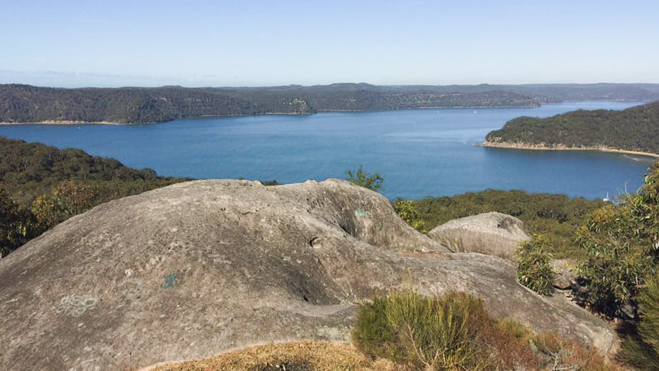
– Wambina Nature Reserve Matcham –
Distance: 7.46 km: Elevation Gain: 374 m.
Starting Point – Northern end of Matcham Road. Coordinates: -33.40614, 151.43922
Using coordinates in Google Maps, be sure to start with a minus sign; type a space after the comma; no full stop at the end of the numbers, as shown above. Then, open Google Maps and type the coordinates into the box – “Search Here” click “Directions” and finally click “Start”.
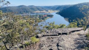
The track is clear and a moderate climb to the reserve’s ridge. The deep gorges on the eastern side, as you will see on the trail of the trail, protect the many and varied species of birds in this reserve. On this bush walk, you will have filtered views from the ridge paths at the apex. Particularly, check out Tuggerah Lakes to the north. The rainforest escarpment on the southeast is the headwater of the Erina Creek, which meanders downhill through Matcham and under the bridge at East Gosford into Brisbane Water. Tall timbers, which include Ironbark and Turpentine, provide welcome shade on the trails. A walking pole will assist with steeper sections, and a spray with Deet40 will keep leeches at bay.
Sydney Awards Netball Trophy Page sponsors this walk: Find a Netball Club
Berrys Head Loop Trail
Distance: 6.0 km: Elevation Gain: 247 m
Starting Point – NE end of Berrys Head Road. Coordinates: -33.39255, 151.35806
Using coordinates in Google Maps, be sure to start with a minus sign; type a space after the comma; no full stop at the end of the numbers, as shown above. Then, open Google Maps and type the coordinates into the box – “Search Here” click “Directions” and finally click “Start”.
This map extends the suggested Berrys Head Trail. The 6 Km trail indicated here is a medium walk offering a variety of tracks.
Enjoy the peace as you pass through dry and wet forest areas.
The remnant rainforest around the Wyoming Creek headwater sector appears to be a two-tier forest. In particular, Strangler Figs, tall Ironbark and Blackbutt trees deliver plenty of shade.
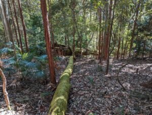
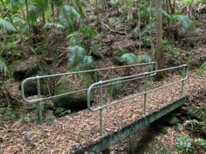
Four small well-maintained bridges traverse the creeks so as to make the tracks on this route more straightforward and easier.
You will notice that I have shown two possible starting points. Both of these trailheads have adequate parking. In the case of waypoint number two, the ascent to Berry’s headland is shorter.
You will catch this space’s peaceful feel bushwalking through the differing mini-climates.
The Berry’s Head walk is sponsored by Sydney Awards & Trophies – Glass and Crystal Awards Page.
Scenic Walk in Muogamarra Reserve
Distance: 7.27 km: Elevation Gain: 223 m
Starting Point – Pacific Hwy near “Pie in The Sky”. Coordinates: -33.57417, 151.43922
Using coordinates in Google Maps, be sure to start with a minus sign; type a space after the comma; no full stop at the end of the numbes, as shown above. Then, open Google Maps and type the coordinates into the box – “Search Here” click “Directions” and finally click “Start”.
Finchs Line Wiseman’s Ferry
Distance: 8.35 km: Elevation Gain: 223 m
Starting Point – Finchs Line Trailhead, Wisemans Ferry Road. Coordinates: -33.39265, 150.99782
Using coordinates in Google Maps, be sure to start with a minus sign; type a space after the comma; no full stop at the end of the numbers, as shown above. Then, open Google Maps and type the coordinates into the box – “Search Here” click “Directions” and finally click “Start”.
Early Colonial History
Point Clare to Spike Milligan Bridge Bush walk via the Hieroglyphs
Distance: 11.36 km: Elevation Gain: 401 m
Starting Point – Western end of Penang Street, Point Clare. Coordinates: -33.44081, 151.32654
Using coordinates in Google Maps, be sure to start with a minus sign; type a space after the comma; no full stop at the end of the numbers, as shown above. Then, open Google Maps and type the coordinates into the box – “Search Here” click “Directions” and finally click “Start”.
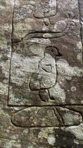
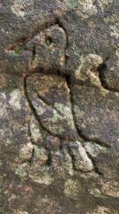
The highlights were a visit to the hieroglyphics site and then to Waterfall Bay. Following your trail to the south, you will find a ridge overlooking Woy Woy Bay with views of Spion Kop and Mount Wondabyne.
Rock Art from another Era
The Hieroglyphics Walk is sponsored by Sydney Awards & Trophies – Plaque Award Pages
Infinity Pool and Basalt Trail
Distance: 9.35 km: Elevation Gain: 586 m
Starting Point – Corner Tunnel Trail and Woy Woy Road. Coordinates: -33.4813, 151.29495
Using coordinates in Google Maps, be sure to start with a minus sign; type a space after the comma; no full stop at the end of the numbers, as shown above. Then, open Google Maps and type the coordinates into the box – “Search Here” click “Directions” and finally click “Start”.
 This loop is an outstanding walk. Getting down to the trough pool via the rock access can be challenging for some people. To assist with the minor descent onto the ledge, a rope is available.
To ensure safety, it is important to exercise caution when walking on the ledge, especially when conditions are wet and slippery. Before bush walking on this trail, check your weather forecast leading up to your walk.
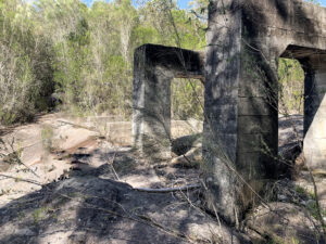
Given these points, the rest of the walk along the old Basalt Rail is a joy with many infrastructures of the basalt mining operation.
Bushwalking back in time.
Some small bridging structures were present when we arrived at the small creek. At this point, the rails are not present. As you continue along the path, you may come across other remnants of the past. This particular mine produced basalt used for road construction and operated for approximately two years before being shut down around 1930. The trail joins the Great North Walk above the Waste Disposal Facility at Woy Woy and loops back to the Tunnel Trail. Start as early as possible in the Summer months.
Sydney Sporting Supplies Rugby Trophies Page sponsors the Infinity and Basalt Rail Walk – Find a Rugby Union Club – Find a Rugby League Club
Umina Ridge via the Van Dahl Firetrail Loop
Distance: 8.06 km: Elevation Gain: 243 m
Starting Point – Corner Van Dahls Firetrail and Patonga Drive. Coordinates: -33.53592, 151.28518
Using coordinates in Google Maps, be sure to start with a minus sign; type a space after the comma; no full stop at the end of the numbers, as shown above. Then, open Google Maps and type the coordinates into the box – “Search Here” click “Directions” and finally click “Start”.
 The walk is best done in early spring. The wildflowers are blooming, and the colours are astonishing. It is an easy walk on the fire trails; however, the smaller tracks can be overgrown and close. You can wear gaiters if you have them for the closed-in trails, as there may be the occasional snake. Apart from the free and profuse flower display, the view of Lion Island and beyond is majestic. The combination of wildflowers and expansive areas to the south makes this one of the best bush walks on the Central Coast.
The Umina Ridge Loop is sponsored by Sydney Sporting Supplies Crystal Awards & Trophies
Increase your knowledge – The difference between Crystal and Glass – All you need to know about Crystal Trophies
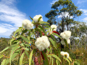
Spring Flowers at The Waratah Patch and The PMG Firetrail
Distance: 3.06 km: Elevation Gain: 74 m
Starting Point – Corner Warrah Trig Road and Patonga Drive. Coordinates: -33.54062, 151.28179
Using coordinates in Google Maps, be sure to start with a minus sign; type a space after the comma; no full stop at the end of the numbers, as shown above. Then, open Google Maps and type the coordinates into the box – “Search Here” click “Directions” and finally click “Start”.
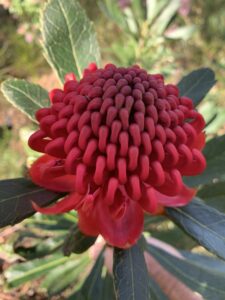 As events go on the Central Coast, wildflowers and waratahs are spectacular. You won’t want to miss the stunning late-winter blooms on display.
Known as The Waratah Patch by residents, this is one of the best spots in the National Park to see these vibrant-red blooms. At the same time, many of the wildflowers are also in blossom. The mapped walk along the PMG Firetrail is a showcase.
For the most part, many species of colourful flowers create a floral avenue along the fire trail.
To maximise your bushwalk, take some photos. You could drive southeast and park near the trig after returning to your car. The coastal views are spectacular.
Spring Flowers at the Waratah Patch is sponsored by Sydney Sporting Supplies – Achievement Trophies
Daleys Ridge Circuit via Daleys Point Trail and Rocky Point Trail – a bush walk
Distance: 10.90 km: Elevation Gain: 318 m
Starting Point – Maitland Bay Drive Daleys Point. Coordinates: -33.51548, 151.37455
Using coordinates in Google Maps, be sure to start with a minus sign; type a space after the comma; no full stop at the end of the numbers, as shown above. Then, open Google Maps and type the coordinates into the box – “Search Here” click “Directions” and finally click “Start”.
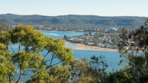
The majority of this walk was off-trail on the bike tracks. Although these MTB courses looked tough in places, they were easy to navigate. Good walking shoes are required as some areas require traction, and one walking pole will assist on some of the descents. The tracks are excellent for a bush immersion feel. The well-forested sector near the Brisbane Water is alive with the pingining of the Bellbirds. The route in this sector is cool as it winds upward towards Stroms Lookout. There are many vantage points to photograph the magnificent Brisbane Waters. Overlooking Daleys Point, Aboriginal rock art is fading fast but worth visiting.
Sponsored by Sydney Sporting Supplies – Aussie Rules Page. Find an Aussie Rules Club near you.
A Short Walk on the North Avoca Trail
Distance: 4.71 km: Elevation Gain: 46 m
Starting Point – Near the roundabout, Cnr Charles Kay Dr & Scenic Hwy, Terrigal. Coordinates: -33.44880, 151.42993
Using coordinates in Google Maps, be sure to start with a minus sign; type a space after the comma; no full stop at the end of the numbers, as shown above. Then, open Google Maps and type the coordinates into the box – “Search Here” click “Directions” and finally click “Start”.
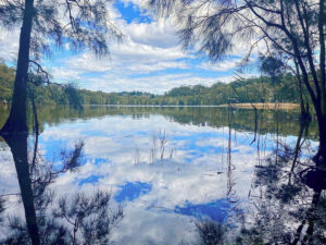
This short walk is one way downhill all the way. The 1st half traverses a cool forested valley as it follows mountain bike trails down to the Avoca lagoon. After about 2.5 Km, you will find a Grey Flying Fox colony. The walk is full of waterfowl and other bird life. The last 1 km is a pleasant suburban walk from the lagoon to the North Avoca beach.
The walk is mapped as one way walk. However, why not make it a two way trek? In this event, park at the beach and stroll up first and then return to the beach for a swim.
A point often overlooked is the ground-level “engineering” of the bike tracks going down the slope to the lagoon. The trail is one of the first tracks in the region beaten by many keen cycle riders over the decades. I will leave it to others to discuss the rights of passage on this occasion.